So, what exactly is Crown land?
Put simply, it's public land. It's owned by either the federal or provincial government on behalf of every single Canadian. You can think of it as our country's shared backyard—a massive, wild expanse managed for everything from conservation and industry to incredible recreational opportunities. For hunters, it's paradise.
Your Guide to Understanding Canadian Crown Land
For anyone who hunts in Canada, getting a handle on Crown land is the first step to unlocking millions of hectares of prime territory. It's the difference between a successful, ethical hunt and a frustrating—or even illegal—one. These public lands are a core part of our Canadian heritage, offering incredible access to the wild places where big game, waterfowl, and upland birds live.
But the term "Crown land" isn't a free-for-all pass. Its management is a complex patchwork of federal and provincial jurisdictions, and each one comes with its own set of rules, regulations, and access rights. This guide is built to cut through that complexity.
What This Guide Covers
We’re going to break down everything a hunter needs to know, starting with the basics and moving into the practical skills you'll need on the ground. You'll learn about the different types of Crown land, how to tell them apart, and most importantly, why those distinctions matter for your hunt.
This guide will help you:
- Understand the sheer scale of Crown land and the opportunities it holds.
- Figure out who manages the land in your province and why that's so critical.
- Know the difference between a general-use area and a restricted zone.
- Learn how to confidently find and verify Crown land boundaries.
- Follow the key rules for hunting responsibly on our public lands.
The old way of navigating Crown land meant wrestling with clunky government websites and squinting at paper maps. Thankfully, modern tools have completely changed the game, putting precise, easy-to-read boundary information right in the palm of your hand.
To give you a quick reference point as we dive deeper, here’s a simple table summarizing the key concepts we'll be covering.
Crown Land at a Glance
| Concept | What It Means for a Hunter |
|---|---|
| Public Ownership | The land is owned by the government, meaning you generally have the right to access it for hunting and recreation. |
| Federal vs. Provincial | Most huntable Crown land is managed by the province, so provincial hunting regulations are your primary guide. |
| Land Use Categories | Not all Crown land is the same. Some areas are open for general use, while others have restrictions or are protected. |
| Access Rights | Your right to hunt depends on the specific land designation, local bylaws, and any active industrial leases. |
| Boundary Verification | It's your responsibility to know exactly where you are. Crossing onto private land without permission is trespassing. |
This table is just the starting point. Let’s get into the specifics of how you can use this knowledge to your advantage.
Navigating With Modern Tools
Throughout this guide, we'll highlight how mapping apps like HuntScout are making it easier than ever to explore Crown land with total confidence. These tools take complicated provincial data and turn it into simple, user-friendly map layers.
They completely eliminate the guesswork. You can plan your entire hunt from your couch, pinpoint access points, and navigate in the field knowing you are exactly where you're supposed to be.
With that foundation, you’ll be ready to explore these shared lands safely, ethically, and effectively. Let's start by digging into the true scale of this incredible public resource.
The True Scale of Canada's Public Hunting Grounds
To really get a handle on what Crown land means for a hunter in Canada, you need to think big. I mean, really big. This isn't just a few scattered woodlots or the odd regional park. We're talking about one of the largest networks of public land on the planet—a core piece of our national identity and, frankly, a hunter's greatest asset.
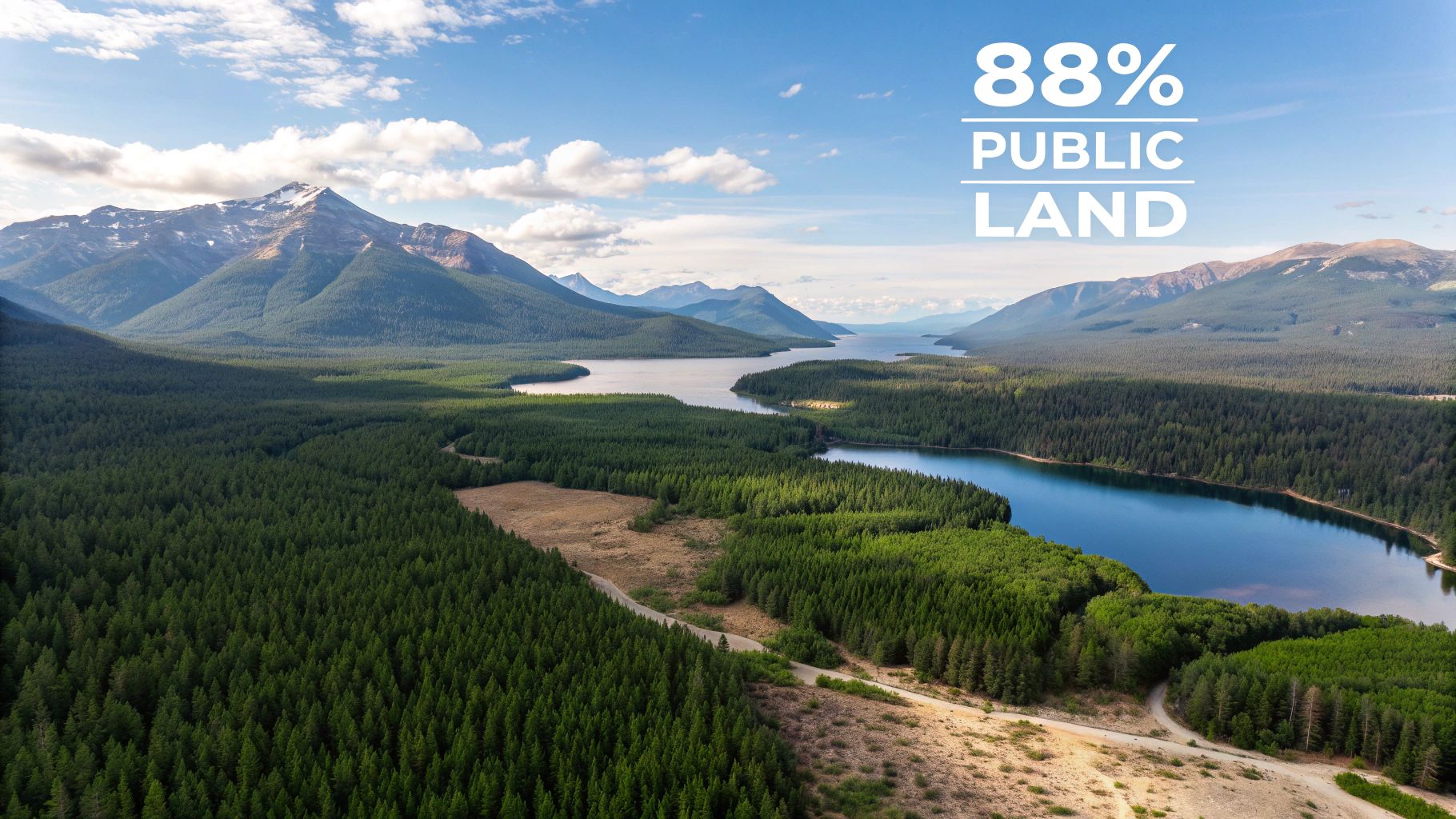
When people say Crown land is vast, the numbers are almost hard to believe. It blankets about 88% of Canada's total area, an almost unimaginable territory for exploration, conservation, and recreation. It’s the sprawling boreal forest, the rugged mountain ranges, the open prairies, and the pristine wetlands that truly define the Canadian wilderness.
This isn’t just empty space on a map, either. It's living, breathing habitat that supports healthy populations of big game like moose, elk, and deer, not to mention countless opportunities for hunting waterfowl and upland birds. For Canadian hunters, this public trust translates directly into freedom and opportunity.
A Province-by-Province Breakdown
The enormous scale of Crown land becomes much more tangible when you look at it from a provincial level. While the national figure is impressive, the stats for each province really drive home just how accessible this resource is, no matter where you plan to hunt.
The sheer dominance of public land means that in many parts of the country, you're never all that far from a potential hunting spot. Just look at these provincial numbers:
- Newfoundland and Labrador: An incredible 95% of the province is Crown land, offering some of the most remote and wild hunting experiences in North America.
- British Columbia: Home to towering mountain ranges and dense coastal forests, 94% of BC is public land, providing more backcountry adventure than one could experience in a lifetime.
- Ontario: A staggering 87% of Ontario is designated as Crown land, which opens up endless opportunities for everything from deer hunts near the south to fly-in moose expeditions up north.
Even in provinces with more agriculture or urban sprawl, Crown land still makes up a huge portion of the landscape. It provides critical access for hunters who might otherwise be stuck knocking on doors for private land permission.
Putting the Numbers in Context
These percentages aren't an accident; they have deep historical roots tied to how Canada developed as a nation. The idea of holding land in the public trust has been central to our country's identity for generations.
Crown land is more than just a statistic; it's a shared public heritage. It represents a promise to preserve wild spaces and ensure that every Canadian has the chance to connect with nature through activities like hunting, fishing, and camping.
Modern data backs up this legacy. Recent estimates confirm that about 82% of Canada's total land area—that's roughly 8,886,356 square kilometres—is Crown land. It’s split between about 6% federal and an overwhelming 76% provincial Crown land, which is what most of us hunters will be dealing with. For a big-game hunter in Ontario, this is pure gold, since 87% of the province is publicly owned and largely accessible. For a deeper dive, you can explore historical land use data from Statistics Canada to see how it all evolved.
This massive scale guarantees that with the right knowledge and a good map, you can find your own piece of the wilderness. It all starts with understanding what Crown land in Canada actually is, because it's the very foundation of our hunting traditions. Now, let’s dig into who actually manages all this land.
Who Manages Crown Land and Why It Matters to You
Figuring out who holds the keys to Crown land isn’t just a bit of trivia; it’s one of the most critical things a hunter needs to know. Think of all Crown land as a massive family estate. While it technically belongs to every member of the family (that's the Canadian public), different relatives are put in charge of managing specific parts of the property. This division of labour directly impacts where you can go, what you can do, and which rules you have to follow.
This management structure is split between two main levels: federal and provincial. For the vast majority of us looking for a place to hunt, it’s the provincial governments that call the shots. The federal government manages a relatively small slice of the pie, about 6% of all Crown land, which covers things like national parks, military bases, and other lands set aside for federal use. Generally, these are areas that are either off-limits or heavily restricted for hunting.
The real action for hunters happens at the provincial level. The provinces control roughly 76% of all Crown land in Canada, and this is the land you'll most likely be scouting, hiking, and hunting on.
The Provincial Gatekeepers of Your Hunt
Every province has its own ministry or department tasked with managing public lands and natural resources. These are the folks who set the specific rules for access, hand out the permits, and enforce the hunting regulations within their borders.
Knowing the name of this governing body in your province is your first step to staying on the right side of the law. Here are a few of the big ones:
- In Ontario, the main authority is the Ministry of Natural Resources and Forestry (MNRF).
- Out in British Columbia, the Ministry of Forests, Lands, Natural Resource Operations and Rural Development is in charge.
- In Alberta, public lands and hunting regulations fall under Alberta Environment and Parks.
These provincial bodies juggle everything from forestry operations and mineral leases to creating conservation reserves and designating general-use areas. It’s their decisions that create the complex patchwork of land classifications that can make navigating Crown land feel so overwhelming without the right tools.
The specific designation of a piece of Crown land determines your rights as a hunter. A general-use area might welcome you with open arms, while an adjacent parcel—also marked as Crown land—could be a protected conservation reserve where hunting is strictly forbidden.
From Dusty Ledgers to Digital Maps
This system of tracking and managing millions of hectares of land is incredibly complex, with a history stretching back over a century. The data defining these boundaries has been collected, updated, and re-catalogued for generations.
Take British Columbia, for example, where meticulous records of Crown land have been kept since the 1850s. This information was finally digitized in the 1980s and now forms the backbone of modern databases that track everything from land surveys and tenures to administrative boundaries. You can get a sense of how BC manages this vast registry of Crown land data online.
This historical context is exactly why knowing a spot is "Crown land" isn't enough information. That land could be leased for mining, earmarked for forestry, or set aside for conservation, all of which change the rules of access for you. Without a tool that can interpret this ocean of often confusing provincial data, a hunter is basically walking in blind. This is precisely why modern mapping apps like HuntScout have become so essential—they translate all that complicated information into clear, actionable maps that tell you exactly where you can and cannot go, keeping you safe and legal.
Knowing the Difference: General Use vs. Restricted Crown Land
One of the classic rookie mistakes is thinking all Crown land is fair game for hunting. This is where the simple idea of "public land" gets a lot more complicated. Just because a piece of ground is publicly owned doesn't mean it's a free-for-all. Crown land is actually a patchwork of different categories, and each one comes with its own rulebook.
A good way to think about it is like the different zones in a city. You've got public parks for picnics, commercial zones for shops, and residential areas for homes. It's all part of the same city, but you can't just pitch a tent in the middle of a shopping mall. Crown land works the same way, with specific zones set aside for different purposes.
For any hunter, the single most important distinction to grasp is the one between General Use Crown Land and the various types of restricted areas. Getting this right isn't just about finding a good spot—it's about staying on the right side of the law.
The Green Light: General Use Crown Land
For most of us hunting on public land in Canada, General Use Crown Land is our bread and butter. This is the land that the province manages with fewer strings attached, making it the go-to for hunting, fishing, and camping. When you see this designation on a map, it’s usually your green light to head out, as long as you're following all the standard provincial hunting regulations.
These are often massive stretches of forest, wetlands, and open country that haven’t been earmarked for something specific like a park or an industrial site. This is where you’ll likely spend your time scouting for moose, chasing grouse, or finding a promising ridge for a deer hunt.
Red and Yellow Lights: Restricted and Protected Lands
This is where you need to pay close attention and where a good mapping tool is worth its weight in gold. Just seeing "Crown Land" on a map isn't enough information, because that label can cover a huge range of restricted zones where hunting is either heavily controlled or flat-out forbidden.
Here are some of the most common restricted areas you'll run into:
- Provincial Parks and Conservation Reserves: Yes, they're public, but they are set aside for conservation and recreation. Hunting is often banned entirely or limited to very specific areas, species, and seasons.
- First Nations Reserve Lands: This land is set aside for the use and benefit of a First Nation. Access is controlled by the band, and you absolutely cannot hunt here without their explicit permission.
- Leased Lands: A surprising amount of Crown land is leased out for things like logging, mining, or cattle grazing. While it’s still public land, the company holding the lease often has specific rights that can restrict public access for safety or operational reasons.
- Environmentally Sensitive Areas: These are protected zones meant to preserve fragile ecosystems or critical wildlife habitats. To prevent any disturbance, public access—especially for hunting—is almost always off-limits.
It's crucial to get this right. Making a mistake can lead to serious trouble, from a hefty fine for trespassing to damaging a sensitive habitat. The responsibility is always on you, the hunter, to know exactly where you are and what rules apply to that piece of ground.
A Modern Fix for an Old Problem
So, how do you confidently tell a huntable General Use area from a restricted conservation reserve when you're out in the bush? The old-school way involved juggling multiple government websites, downloading clunky PDF maps, and trying to piece it all together. It was a headache and far from foolproof.
This is exactly why a tool like HuntScout has become so essential for hunters. It takes all that complicated provincial land data and translates it into simple, colour-coded layers on a map you can use on your phone. With a quick glance, you can see the huntable areas from the no-go zones. It takes the guesswork out of the equation, helps you avoid accidental trespassing, and lets you hunt with the confidence of knowing you’re in the right spot.
How to Confidently Find and Verify Crown Land Boundaries
As a hunter, your most important job is knowing exactly where Crown land ends and private property begins. For decades, this was a massive headache. You were stuck with a clumsy patchwork of different tools and maps that were almost useless when you needed them most—out in the bush.
The old-school approach was a real grind. You'd spend hours on clunky government websites, trying to piece together a half-dozen PDF maps, all with different scales and years-old publication dates. You might print them out or download a few files, but once you lost cell signal, you were just guessing. You hoped that faded line on your crumpled map was accurate, but you never really knew for sure. It wasn't just frustrating; it left a huge margin for error and the real risk of accidental trespassing.
The Old Way versus The New Way
Let's be honest, the traditional methods for finding Crown land were a barrier for a lot of hunters. The information was scattered all over the place, a pain to access, and even harder to use when you were trying to navigate the backcountry.
These old tools had some serious drawbacks:
- Outdated Information: Paper maps and even some government websites can be years out of date. They don't show recent land sales, new resource leases, or updated conservation areas.
- Useless in the Field: A paper map can't show you where you are. Trying to figure out your exact position relative to an invisible property line in the middle of a dense forest is next to impossible.
- No Integrated Data: You had to use one map for property lines, another for logging roads, and a third for your Wildlife Management Unit (WMU). It was up to you to try and stitch it all together into something that made sense.
Thankfully, technology has finally caught up and given us a much better solution. Modern digital mapping apps have completely changed the game for finding and navigating Crown land in Canada.
Making Discovery Easy with Modern Mapping Tools
Today, specialized hunting apps put all the information you need right in the palm of your hand, turning your smartphone into a powerhouse navigation tool. These platforms are built by hunters, for hunters, and they solve all the problems that made the old way so difficult.
This simple process flow shows how modern tools have taken the guesswork out of exploring Crown land.
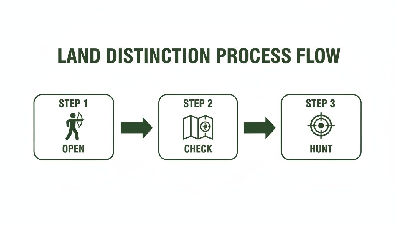
It’s a clear path: find open land, check the boundaries, and hunt with confidence. Having accurate, real-time map data makes it that straightforward.
An app like HuntScout takes this even further by layering all the critical data you need into one simple, intuitive map. Instead of juggling different websites and paper maps, you get a single screen that shows you everything.
By combining Crown land boundaries, private property lines, satellite imagery, and WMU overlays, modern apps remove the guesswork. You can see your live GPS position right on the map, so you always know exactly where you stand.
This technology lets you do some serious e-scouting from your couch. You can identify promising areas, find hidden access points, and see details that were once impossible to find. You can drop digital waypoints for glassing knobs, game trails, or potential stand locations, letting you build a solid hunt plan before you even put your boots on.
Practical Tips for Using Digital Maps in the Field
The real magic of a modern hunting app is how it performs when you're deep in the backcountry. The best ones are designed to work perfectly even when you have zero cell service—which is exactly where you'll find some of the best Crown land hunting spots.
Here are a few tips to get the most out of these powerful tools:
- Download Offline Maps: This is non-negotiable. Before you leave home, save detailed maps of your entire hunt area right to your phone. This guarantees you’ll have full access to all the layers, boundaries, and your saved pins when you’re completely off-grid.
- Use Satellite and Topo Layers: Start with satellite imagery to find clearings, funnels, and water sources. Then, flip over to a topographic layer to really understand the terrain. This helps you spot ridges, benches, and steep slopes so you can plan the smartest approach.
- Confirm Your WMU on the Fly: With a good app, you can just tap anywhere on the map to see which WMU you’re standing in. This is crucial for making sure you’ve got the right tags and are following the specific regulations for that unit.
- Drop Pins at Key Locations: As you scout or hunt, drop pins to mark everything important. Mark where you parked the truck, where you found fresh tracks, a hidden water source, or the spot you harvested your animal. It creates a digital breadcrumb trail to help you navigate with total confidence.
By using a dedicated Canadian hunting app, you turn the complicated task of figuring out what is Crown land in Canada into a simple, confident process. You can explore new country knowing you are hunting legally, ethically, and safely.
Hunting Responsibly on Public Land
The incredible freedom that comes with hunting on Crown land carries an equally heavy responsibility. This isn't private property; these are shared spaces that belong to every single one of us. It’s on us, the hunters who use them, to make sure they stay healthy, accessible, and wild for the generations that will follow in our footsteps.
Being a good steward of the land goes way beyond just buying the right tags. It’s about adopting an ethical code that shows respect for the land itself, the wildlife we pursue, and every other person who enjoys these areas. From the moment you load your truck to the second you pack out the last of your gear, your actions matter.
The Ground Rules Every Hunter Must Know
Hunting regulations can feel a bit overwhelming at times, but a handful of core rules form the bedrock of safe and legal hunting on Crown land. Think of these as the non-negotiables—they’re strictly enforced to keep people safe and protect property.
You’ll find slight variations between provinces, but some rules are nearly universal:
- Firearm Discharge Setbacks: It's almost always illegal to shoot from, along, or across any public road. Provinces also have strict minimum distances for firing a weapon near occupied buildings, and these setbacks can vary quite a bit, so you need to know the local number.
- Vehicle Restrictions: Your truck, ATV, or side-by-side needs to stay on established roads and trails. Tearing off-trail can cause lasting damage to sensitive ecosystems and is usually against the law.
- Camping and Blinds: While you can camp in most General Use Crown land areas (often for up to 21 days in one spot), you can't build a permanent hunting shack. Your tree stands and ground blinds need to be temporary and have to come down when the season is over.
At the end of the day, the official provincial regulations are the final authority. Claiming you "didn't know" won't get you out of a fine. This is where a tool like HuntScout comes in handy—it has built-in links to the official regulation books, so you can double-check the rules for your specific area right from your phone.
Live by the Leave No Trace Philosophy
Beyond the black-and-white regulations, ethical hunting is all about a simple but powerful idea: Leave No Trace. The mission is to leave the wilderness exactly as you found it—or maybe even a little better.
This isn't just about not being a slob. It’s a complete mindset that should guide everything you do on a hunt, from setting up camp to packing out your game. It’s about minimizing your footprint so the next person can have that same incredible, wild experience you just did.
Stewardship in the Real World
So what does this look like on the ground? It's actually pretty simple. Before you head out, make a commitment to follow a few key practices that show you respect the resource.
- Pack It In, Pack It Out: This is the golden rule, no exceptions. Every single thing you bring—food wrappers, spent shells, broken gear—leaves with you. Leaving trash is lazy, illegal, and dangerous for wildlife.
- Handle Your Harvest with Care: When you field dress an animal, do it well away from any water source to avoid contamination. Where regulations require it, pack out every part of the animal. If not, move the remains far from any trails or campsites so you don't attract scavengers or predators.
- Keep Your Impact Small: Stick to existing campsites whenever possible instead of carving out a new one. If you need a fire, use a designated fire pit or a portable stove. The goal is to keep your site small and contained to avoid trampling vegetation.
When you hunt this way, you're doing more than just filling your tag. You're actively playing a part in preserving Canada’s incredible public lands. For more ideas and to see what other hunters are doing, check out the discussions in the HuntScout community forums.
Your Crown Land Hunting Questions, Answered
Even with the best maps in hand, questions always pop up when you're planning a trip or have boots on the ground. Let's tackle some of the most common things hunters ask about Crown land in Canada, giving you clear, practical answers to keep your hunt safe, legal, and stress-free.
Think of this as your go-to guide for those "what if" moments.
Can I Camp Anywhere on Crown Land in Canada?
For the most part, yes—but with some major caveats. Canadian residents can typically camp for free on General Use Crown land for up to 21 days in the same spot each year. But this isn't a blanket rule that applies everywhere; the details can change quite a bit from one province to the next.
You might find camping is off-limits in certain areas due to environmental sensitivities, active logging or mining leases, or other specific land designations. The key is to always check the most current provincial regulations before you pitch your tent. This is where a good mapping app really shines, as it can help you spot restricted zones right away.
Do I Need a Special Permit to Hunt on Crown Land?
This is a common point of confusion. No, you don't need a unique "Crown land permit" just to be there. But—and this is critical—you absolutely must have all the standard provincial hunting licences and tags for whatever you're pursuing in that specific Wildlife Management Unit (WMU).
Crown land is the where, not the what. It’s the backdrop for your hunt, but it doesn't give you a free pass on any of the normal hunting rules. If you're new to all this, linking up with a seasoned hunter is a fantastic way to learn the ropes. Finding people to share knowledge with is easier than ever, especially if you're a first-time hunter looking for a partner.
How Can I Be Sure I’m Not on Private Land?
Staying off private property is 100% your responsibility. "I thought this was Crown land" won't get you out of a trespassing charge. The most surefire way to know exactly where you stand is by using a modern digital mapping tool that overlays your real-time GPS position on a detailed property map.
Government maps are a decent starting point, but they can be a real pain to use in the field and aren't always up-to-date. A purpose-built app is a game-changer because its layers clearly show the lines between Crown land, private property, and other no-go zones.
Using your phone’s GPS, you can see your little blue dot moving across the map in relation to every property line, even when you have zero cell service. It gives you the confidence to navigate the backcountry and focus on the hunt, knowing you're exactly where you're allowed to be.
Ready to explore Canada's vast public lands with total confidence? HuntScout gives you the detailed Crown land maps, WMU boundaries, and offline navigation you need to hunt safely and effectively. Plan your next adventure by downloading the app at https://huntscout.app.